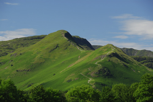
Alfred Wainwright describes Catbells as one of his favourites, which while modest in height, offers splendid views, particularly of Derwent Water. Most of the Wainwright walks to the summit of Catbells start from Hawes End at the foot of the northern ridge, which can be reached by car or by motor launch from Keswick - with a climb up Catbells and a cruise on Derwent Water being a particularly splendid way to spend a day in the Lake District. Stronger walkers and those with a desire to tick off several fells on their Wainwright maps in one day may want to consider pressing on from Catbells to take in Maiden Moor, High Spy, Dale Head, Hindscarth and Robinson - which provide a horseshoe shaped walk which finishes close to the Hawes End starting point in the Newlands valley.
The top of Catbells makes for a very rewarding Lake District Walk, giving a fine panorama with views to Skiddaw, Blencathra, Keswick and Bassenthwaite Lake, as well as fantastic aerial views of Derwent Water, which lies to the east of Catbells. If taking a Wainwright walk up to Catbells alone, even novice walkers should find the trip relatively straight forward, and will enjoy the views at the top which captivated Alfred Wainwright and the many visitors who climb Catbells each year.
The proximity to Keswick and several popular villages near Derwent Water make Catbells a very popular climb, and well worth ticking off your Wainwright maps for the glorious views offered from its top, whether just making a circular route from Hawes End or continuing on to climb the less well known Wainwright fells of Maiden Moor, High Spy, Dale Head, Hindscarth and Robinson.
More information on Catbells and the surrounding fells can be found in Book Five: The Northern Fells by Alfred Wainwright, part of the Pictorial Guide to the Lakeland Fells.

The Wainwright walk to Catbells, a green and pleasant part of the Lake District - Picture by Stewart Smith Photography
Catbells together with all of the Wainwright Fells are included on the Wainwright Fells Map - available in 2 sizes, A2-size (594 x 420mm) or A1-size (841 x 594mm) this Wainwright map is a beautiful pictorial overview of The Lake District National Park. The map shows the locations of all 214 Wainwright fells and includes a complete Wainwright Fell tick-list. Each hill is drawn to scale and is clearly named and numbered in altitude order with its book colour defined. The Wainwright Fells Map is used to record your progress through this exceptional landscape, at the same time it is a functional and informative piece of artwork for the home. Wainwright map details


Plan and record your progress through the Wainwright Fells of the Lake District